And then there were three... Flights are booked, Kyle and I land in Seattle on June 12th, And Patrick follows up on the 13th. Our route will be the Fuhrer finger, And I for one am coming back with a vengeance. The last attempt on this route ended shortly after it began bandaging a climbers arm after helping him out of an extremely large avalanche around 7800 feet on the Wilson Glacier. Just weeks prior the mountain had received 6 feet of new snow, followed by record high temps.
This year, conditions seem to be shaping up nicely. We will have the SPOT tracking device with us so you will be able to follow our every move from the comfort of your warm home... More details to come.
And also, Sad news from the Pyrenees. Two Climbers fell into a crevasse at around the 10,000 foot level and perished. A third climber who went for help has survived. RIP
Thursday, May 20, 2010
Tuesday, March 9, 2010
Its Spring again...
The snow on the East Coast is melting and the Temps are rising... The Pacific Northwest and Rainier Online Forums are beginning to buzz with chat about gear advice, route beta, and the ever present "new guy" asking if he really needs crampons to summit the mountain. The snow that fell on the mountain throughout the past winter is beginning to consolidate, making it relatively "safer" for mountaineers from around the world to begin planning their routes, getting their affairs in order, and starting up the mountain. The same goes for our group of strong climbers from the East Coast. The emails have begun, and yet again the main focus is on Rainier. This year, much like the last, our focus seems to be on the 2000 foot long couloir on the eastern face of the Headwall at 10,000 feet, The Fuhrer Finger route.
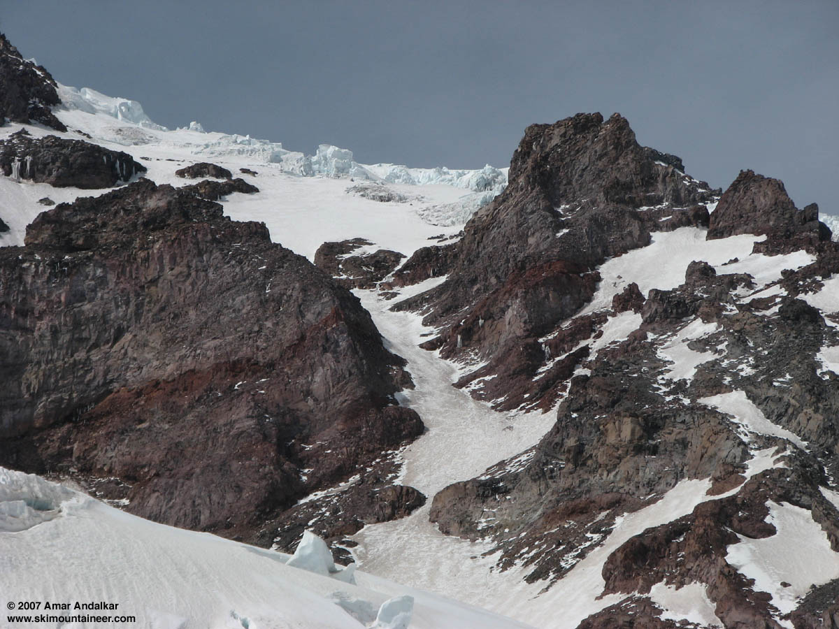
In June of 2008, 4 of us made an unsuccessful attempt at the Finger, Being turned around by a massive wet slab avalanche caused by skiers on the Wilson Glacier shortly after coming up off the Nisqually. The enormous slide stopped about 20 feet from us as we literally ran for our lives away from thousands of tons of snow accelerating towards us. After bandaging up a snowboarder who was caught in the avalanche and spending a night at the base of the slide, it was agreed that it was not safe to ascend any further. We hesitantly descended the next day to Paradise and spent the next night or two at the beautiful Cougar Rock Campground. We did a little sight seeing, had an awesome lunch on the banks of the Nisqually River, and enjoyed some local beer next to warmth of the campfire.
Brian, Rebecca, and I decided to take what days we had left in the Park and make an unplanned jolt up the Disappointment Cleaver towards the summit. Summiting this route in 2007 during extremely high winds gusting to 100 MPH, I was confident I could lead Rebecca and Brian to the summit with ease via the cleaver, as an added bonus the weather report looked fair. We made the 7 hour trek to Camp Muir and spent the night in the Shelter at 10,500 feet. The next morning we made our way across the Cowlitz Glacier with the unstable Cathedral cliffs looming above. Two years prior I was running across the Cowlitz as the cliffs rained down watermelon sized boulders at me. With that event plus the recent avalanche on the Wilson days prior, My nerves were on edge. This time we made the Ingraham Glacier uneventfully, Revealing Little Tahoma and its mesmerizing colors of orange, green, and red Volcanic stone. We geared up and left the Ingraham that night around midnight under crystal clear skies and a bright full moon. That morning I kicked the first steps up the exposed Disappointment Cleaver, an awesome feeling. After making short work of 1,500 feet we stopped for a break as the Sun that was already shining on our families back home began coloring the black sky a fiery red and diminishing the stars.
We began climbing the upper mountain above the cleaver when something to the South caught my eye. The moon which was still casting its erie light on the upper mountain suddenly disappeared. The Mountain which was sitting pretty underneath clear skies hours before, was now encased in a tornado like lenticular cloud which was just spinning around the summit. As we climbed, The ambient light began shining through the clouds, and we found ourselves in a whiteout by 13,000 feet. Moving upward came to a crawl, as it was awfully difficult to see 10 feet in front of you. It was near impossible to judge the degree of the slope or where the snow ended and the sky began, everything was a pale white. We were covered in rime ice from head to toe, and the windchill dropped to around -14 degrees. At 13,500 feet we decided to take a break on a little ledge, and were shortly thereafter joined by a group of RMI clients. At that point we were roughly 910 feet from our goal of the summit at 14,410 feet according to my altimeter.
Once again however, Rainier had a different plan for us. Brian understandably didn't feel 100%, and I know Rebecca was probably as cold as I was. We couldn't move at a fast enough pace safely due to the near zero visibility and we just weren't building up enough heat to keep our bodies warm. It was decided at 13,500 feet that we should descend while it was still an option and while we were all still standing up. Coaxing an ill climber down at 13K is difficult enough in clear weather. Short roping a climber down 2500 feet to our high camp would be nearly impossible without a major rescue effort due to the weather and steep and exposed terrain of the Cleaver. While we all knew just how close we were, we began the extremely slow descent. Each step had to be 100%. Secure, Solid, and confident.
We broke through the lenticular as we reached the top of the Disappointment Cleaver. We took a short break to hydrate and continued down. The sun was now shining over us and offered a welcomed warmth. Unfortunately, That warmth had already penetrated the snowpack and each step down the cleaver was like sliding into home plate. The soft snow balled up underneath our crampons every step. During the warmth of the day, Ice, Rock, And snow become extremely unstable. This melt causes avalanches, rock fall, and massive seracs to tumble. We gained the nose of the cleaver and took 2 minutes. Once crossing the nose back towards the Ingraham, its all gas and no brake. It is well known that you do not stop for anything in this area as it is a bowling alley of rock and ice fall, especially in the warmth of mid day. This area claimed 11 lives in 1981 when a massive ice fall began on the upper Ingraham, and buried their bodies under the ice, never to be found. We successfully made it across and back down the Glacier to our tent. We packed up and made the 10 mile trek back out to Paradise where Becky was waiting with some gifts for all of us! Another successful trip in the books, no summit, but we were all back down safely.
You can see video which we filmed for http://www.visitrainier.com/ , along with pictures from the climb in our blog from Friday, January 9, 2009. Check it out.
In June of 2010 we will be back, Making another attempt at the Fuhrer Finger. Dates are to be determined, as is the final team (s). There could be as little as 3 of us....and it looks like there could be as many as 8 of us. Our blog will be updated as we get things in order and make some trips up to Mt. Washington to train, get some riding done in Tuckerman Ravine, and maybe some rock climbing in the Valley.
Till next time...
Monday, April 13, 2009
Some Easter ice and a dog rescue


Tuesday, January 27, 2009
Memorial Ceremony for 10 Turkish mountaineers killed in avalanche
 Ten mountain climbers were killed and several others were trapped under the snow on Sunday after they were caught in an avalanche on Mount Zigana in the province of Gümüşhane, near the Black Sea coast. They were part of a group of around 20 people hit by the slide and were members of a mountaineering club from the nearby province of Trabzon taking part in a snow festival held on the mountain over the weekend. Yesterday's ceremony was attended by State Minister Murat Başesgioğlu, Minister of Public Works and Housing Faruk Nafiz Özak, main opposition Republican People's Party (CHP) Deputy Chairman Cevdet Selvi, Trabzon Gov. Nuri Okutan, Gümüşhane Gov. Enver Salihoğlu, Trabzon Mayor Volkan Canalioğlu, a number of deputies, army officers and bureaucrats and more than 3,000 local residents. The remains of the
  hikers were sent to their hometowns for burial.
Thursday, January 22, 2009
Lincoln remains on the list, and Tragedy on Mt Hood
Well, Sat 1/17 we awoke to to -29 degree weather in Franconia NH. With a 5 MPH breeze it put the windchill down in the -50's. Warmed up the car and hit up the continental breakfast, passed through town for another cup of coffee, and off we went down 93 to the trail head. I quickly learned a half mile in that the SPOT tracking beacon works better when you don't loose it. Whoops. We dropped off the trail and bushwhacked through some THICK pines into the gully. Ankle deep powder quickly turned to knee deep and after a couple close calls falling through the ice we found ourselves sinking to our chests in powder. A few miles in, Lincoln won, and we backed off at 1:30 knowing that once the sun fell, the temps wouldn't be far behind. Not willing to risk someone falling into the river in -20 degree weather, we hiked down in the sun and called it a day with some pizza and beer. All in all it was a great hike on a beautiful sunny (although bitter cold) day. And one hell of a workout. We'll be back.
Yesterday (1/21/07) a two person team climbing Mount Hood was hit by ice fall near the "Hogsback" around 10,000 feet. 31 year old Brooke Colvin was struck by ice while climbing with her husband Stavn. Stavn watched her get thrown down the mountain after being struck. He was able to down climb to his wife, But she had been killed instantly. A Blackhawk was called in but later called off when the Rescue turned to a recovery. Crews were headed up the mountain Wed afternoon to recover Colvins Body. This is just days after a climber was struck by ice on the same area of Mt Hood. The 45 year old climber was airlifted off the mountain. RIP Brooke, and condolences to Stavn.
Yesterday (1/21/07) a two person team climbing Mount Hood was hit by ice fall near the "Hogsback" around 10,000 feet. 31 year old Brooke Colvin was struck by ice while climbing with her husband Stavn. Stavn watched her get thrown down the mountain after being struck. He was able to down climb to his wife, But she had been killed instantly. A Blackhawk was called in but later called off when the Rescue turned to a recovery. Crews were headed up the mountain Wed afternoon to recover Colvins Body. This is just days after a climber was struck by ice on the same area of Mt Hood. The 45 year old climber was airlifted off the mountain. RIP Brooke, and condolences to Stavn.
Friday, January 16, 2009
MLK weekend climbing & spot tracking
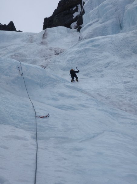
As a reminder, Here is the link you must follow to view our position and track via the Spot satellite locator. Check the link for updates this weekend (1/17-1/18) as we go up "Lincoln's Throat" on Mount Lincoln in Franconia, NH. Its sure to be an interesting climb with a pitch or two of vertical ice (WI2-3) at about 4000 feet, forecasted Artic temps, and possibly some snow. If all goes as planned we should top out at 5089 feet late Saturday afternoon and descend via the falling waters trail. Then to the "Flume" Sunday morning for some ice.
http://share.findmespot.com/shared/gogl.jsp?glId=02jKfbrqLJzkn2RgvnHuzfDzkOACI6EDP
http://share.findmespot.com/shared/gogl.jsp?glId=02jKfbrqLJzkn2RgvnHuzfDzkOACI6EDP
Friday, January 9, 2009
Our 2008 Rainier climb for VisitRainier.com
Here is a link to photo's and video's which were used for the website www.visitrainier.com
A brief trip report can be found on the photo page.
Photo's:
http://www.visitrainier.com/index.php?&gigpag=gallery_sypniewski
Video's:
http://www.visitrainier.com/index.php?&gigpag=videos
(There are 3 video's. One promo, and parts I and II located in the second row of video's)
A brief trip report can be found on the photo page.
Photo's:
http://www.visitrainier.com/index.php?&gigpag=gallery_sypniewski
Video's:
http://www.visitrainier.com/index.php?&gigpag=videos
(There are 3 video's. One promo, and parts I and II located in the second row of video's)
The new Spot Satellite Messenger

The company's moto is "Live to tell about it". Open the box, and you get the comforting (??) message, "Opening this box is this first step to making sure you don't come home in one." The Spot satellite messenger will give family and friends the ability to track our position using Google Maps. Using a combination of GPS satellites and Spot's own network, you will be able to see a preset "OK" message along with our latitude and longitude. By clicking terrain or satellite on Google Maps you will have a good idea of where exactly we are on the mountain or during our training climbs at any given time. This also provides the technology to alert 9-1-1 for any life-threatening emergencies in locations without cellular or wireless coverage.
I have begun testing the unit and will continue to use the tracking feature on upcoming trips. So far the unit has worked flawlessly. All "OK" and "HELP" messages have gone through very quickly. Obviously I hope to never find out if the 9-1-1 function works.
At any time, you can go to the following guest web address and view our most current locations and climbs. The link will be updated prior to our Attempt on Liberty ridge. Any question about the website, Send me an email.
Click the following link:
http://share.findmespot.com/shared/faces/viewspots.jsp?glId=02jKfbrqLJzkn2RgvnHuzfDzkOACI6EDP
Subscribe to:
Posts (Atom)